Everest Base Camp Trek
15 days, Kathmandu to Kathmandu

Itinerary
Day 1Kathmandu
Arrive in Kathmandu at any time. Attend the group welcome meeting.
Your Welcome Moment: Meet Your CEO and Group
Your opportunity to meet your CEO and fellow travellers, and learn more about your tour. Opt to join the group for a local meal afterwards. Don't forget to see the notice in the lobby (or ask reception) for the official time and place to meet up with the group.
Accommodation
Below is an example of the hotel we may use in this city. For the actual hotel your specific departure will be using, please check your voucher.
Hotel Traditional Comfort (or similar)
Day 2Kathmandu/Ramechhap
Drive across the beautiful Nepalese countryside as we depart Kathmandu for Ramechhap. While today may be a longer travel day, it means you get to see the amazing beauty of of Nepal.
Free Time
Enjoy a free afternoon in Ramecchap. Elevation: 475m.
Private Vehicle
Settle in and scan the scenery from the convenience of a private vehicle.
Accommodation
Shangri-La Guest House (or similar)
Day 3Ramechhap/Phakding
The mountain flight into Lukla is spectacular and the landing an exciting beginning to the trek – one end of the runway is 60m (197ft) higher than the other. The flight is on a small Dornier / Twin Otter flight and flight duration is generally around 25 – 30 minutes. Once in Lukla, head through pine and cedar woods along the Dudh Kosi to Phakding. Spend the next three nights trekking in the area and acclimatizing in preparation for heading to base camp. This is a challenging trip and involves difficult trekking at high altitudes but the whole experience is simply awe-inspiring!
ALERT: The Civil Aviation Authority of Nepal regularly switches back and forth from allowing domestic flights to Lukla departing out of Kathmandu airport versus departing out of Manthali airport. The flight used for each individual departure will be determined by what the Aviation Authority is permitting at that time.
In the Himalayas weather can cancel or delay the scheduled flight(s) to/from Lukla airport. To be sure that you make your trek, or return from it, it may be necessary to make this flight by a chartered helicopter. Helicopters can operate in some weather that aircraft cannot. Should a helicopter be needed, it will be at the expense of the travellers, and not something covered by G Adventures. Please keep approximately USD 500 (one way) accessible in case this situation presents itself. This suggested amount is in addition to the emergency fund suggested in the tour details.
Hopefully weather delays will not occur, or if they do it will be for a limited time. Should the delays stretch into days and neither helicopter nor flight are a viable option, a collective decision will be made by the group on how to proceed. This is especially true if the delays are prior to the trek, as the original trek may no longer be feasible. Your CEO will be there to help with this process.
Everest Base Camp Trek Lukla to Phakding
In Lukla, meet up with the porters before heading off on the trek towards Phakding. Follow the Dudh Kosi, the river that flows down from the Himalayas, crossing hanging bridges along the way. Pass camps and keep an eye out for the mani stones, boulders carved with Buddhist inscriptions. The hike is approximately 4 hours, descending gradually to Thado Koshi for around 2 hours. Then the group will begin the first ascent of the trek which is gradually uphill to Phakding (2610m). This portion will take another 2 hours.
Walking distance - 8kms. Time 3-4 hours. Elevation loss - 250m
Terrain: mostly rocky and uneven with some parts being quite steep and narrow. It's a gradual descent with some uphill sections.
Plane
Look! Up in the sky! It's a bird! It's a plane! It's... yup, it is a plane, actually.
Accommodation
Hotel Camp de Base (or similar)
Day 4Phakding/Namche Bazaar
Hike to Namche Bazaar, gateway to Everest Base Camp and spend two nights acclimatizing for the trek. The group will hike mostly uphill today from Phakding and it will take around 7-8 hours to reach Namche Bazaar.
An acclimatisation day allows for an excursion to Thame and Khumjung, the green village.
Everest Base Camp Trek Phakding to Namche Bazaar
Trek from Phakding to Namche Bazaar (3440m). The terrain of today’s hike is mostly uphill with several steep sections and a few narrow suspension bridges over Dudh Koshi River. The trail will pass through pine forests and offer occasional views of the snow capped peaks in the distance.
Spend the remainder of the day in Namche Bazaar acclimatising to the altitude. There are also treks to the surrounding villages of Thame and Khumjung; these short day walks are designed to give us time to get used to high-altitude trekking. Keep your eyes open -- this is the first opportunity to catch a glimpse of the peak of awesome Mt. Everest, the highest mountain in the world.
Walking distance - 12kms. Time 7-8 hours. Elevation gain - 830m
Terrain: mostly uphill, with several steep sections, pine forests, and suspension bridges
Accommodation
Hotel Camp de Base (or similar)
Day 5Namche Bazaar
During today's acclimatization day the group will hike up to Syangboche at 3860m. Weather permitting, you will be able to spend some time here and enjoy tea or coffee while viewing the mighty Himalayas and of course Everest Peak. Return back to Namche where the remainder of the day is yours to rest as you please.
Total time spent hiking today will be around 3.5 hours.
Namche Bazaar Acclimatization Day
Today we have our rest day at Namche. The group will do a short hike to Syangboche which is around 3860m. The total hiking duration will be around 3 hours. The rest of the afternoon involves free time to wander around Namche Bazaar. There are many opportunities here to learn about Everest Expedition and Sherpa culture during the afternoon time.
Walking distance - 4kms. Time: 3.5 hours. Elevation gain - 420m
Terrain: mostly uphill
Accommodation
Tashi Delek Lodge (or similar)
Day 6Namche Bazaar/Thyāngboche
Set out on a 6-7 hr trek through pine and rhododendron forests before arriving in Tengboche. Tengboche is a small village, and home to the famous Tengboche Monastery, the largest monastery in Khumbu region.
Everest Base Camp Trek Namche Bazaar to Thyāngboche
The route from Namche to Tengboche (3860m) is unbelievably beautiful – the Dudh Kosi is far below and Thamserku, Kantega, Ama Dablam, Lhotse, and Everest rise in front. Woods, pine and rhododendron forests, mani walls, chorten (stupas), and suspension bridges across the river make this a lovely walk.
Walking distance - 9.5-10kms. Time: 6-7 hours. Elevation gain - 420m
Terrain: Steep ascents and descents, passing through forest of rhododendron, pine and fir trees.
Accommodation
Peaceful Lodge (or similar)
Day 7Thyāngboche/Dingboche
Trek to Dingboche, crossing bridges and rivers with sweeping views of the Himalayan region. Walk through forests and alpine meadows and search for wildlife along the way. The group will spend 2 nights in Dingboche to acclimatize.
Everest Base Camp Trek Tengboche to Dingboche
Follow stone steps that lead down through rhododendrons, birches, and conifers. Due to the hunting ban, almost tame pheasants are regularly seen in this area. At the bottom of the steps lies the small village of Deboche and its nunnery. Rising above the tree line, the trail enters alpine meadows of scrub juniper and, in summer, a profusion of wild flowers. Once the group reaches Dingboche (4410m) they will be treated with outstanding mountain views. This is also the only place in the region where barely is grown.
Walking distance - 10kms. Time: 6-7 hours. Elevation gain - 550m
Terrain: Trail is predominantly uphill with some flat sections and occasional flats. As the group approaches Dingboche, the terrain becomes more rugged and rocky. The vegetation becomes sparse and landscape becomes more rugged and barren the higher the trek goes.
Accommodation
Peaceful Lodge (or similar)
Day 8Dingboche
Today is an acclimatization day. Opt to hike to Chhukung or Nagarjuna Peak (Nangkartshang Peak).
An acclimatization day here can be used to hike up the Imja Khola to Chhukung or Nagarjuna Peak (Nangkartshang Peak), a small summer settlement from where stunning views of Island Peak, Lhotse, Ama Dablam, and the fluted ice walls flanking the Amphu Lapcha pass can be seen. These views are one of the highlights of the entire trek.
Note: Nagarjuna Peak (Nangkartshang Peak) is at 5200 meters, but we only trek half way up to acclimatize.
Dingboche Acclimatization Day
Enjoy some time away from the trek to adjust to the higher altitude. Take it easy, enjoy the scenery, drink plenty of fluids, and prepare for the next day's hiking. Take a short hike to Nagarjuna Peak (Nangkartshang Peak) at 4850m.
Walking distance - 3 kms. Time: 3-4 hours. Elevation gain - 440m
Optional Activities - Day 8 HideShow
Chhukung Hike
Enjoy an optional trek to Chhukung and take in the wonderful scenery as you hike.
Accommodation
National Park Lodge (or similar)
Day 9Dingboche/Lobuche
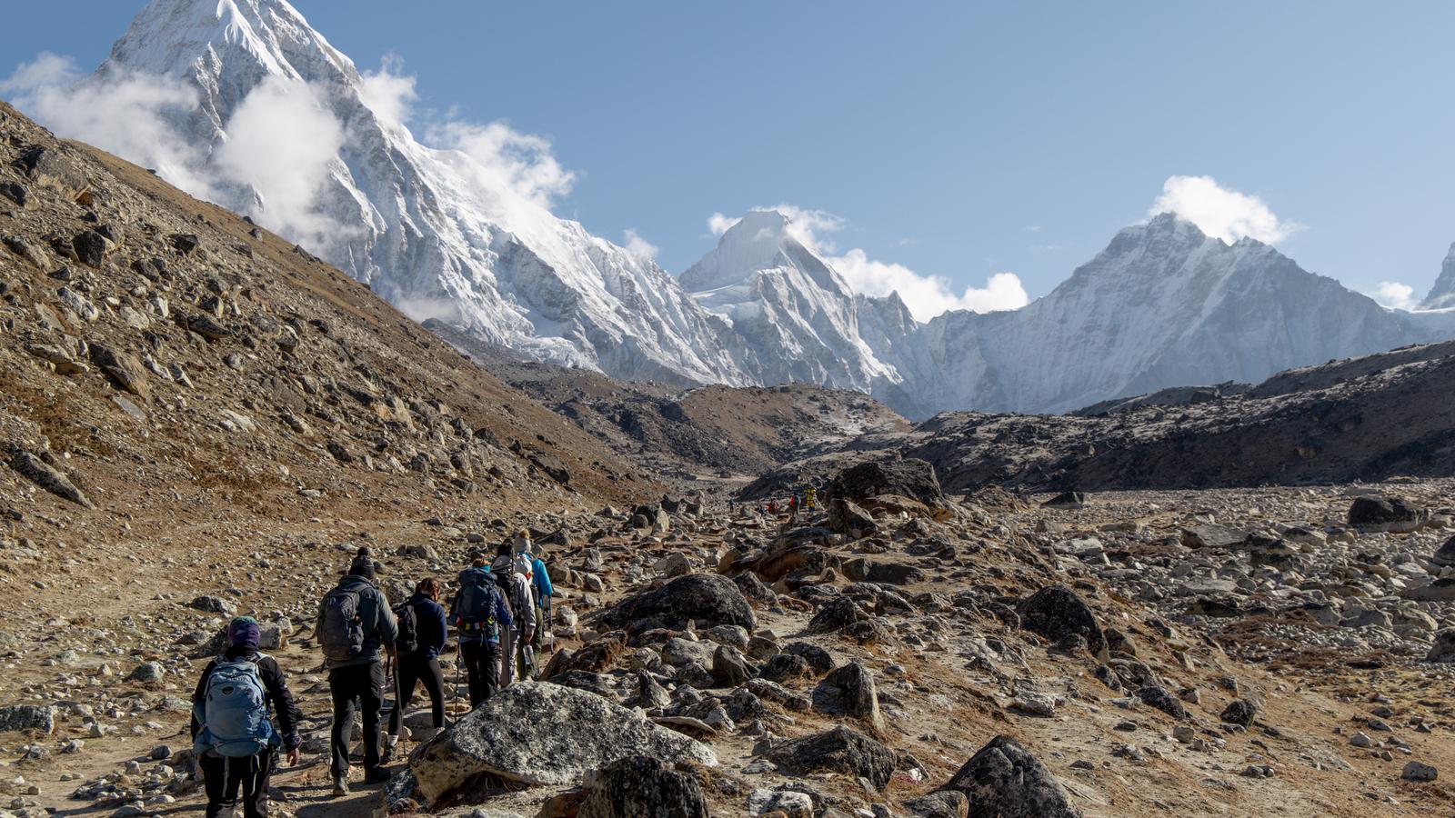
Hike through alpine meadows and summer yak pastures towards the end of the moraine of the Khumbu Glacier to Lobuche, which has spectacular views of Nuptse. Today the group will walk for around 6 hours gradually following the trail uphill along a glacial river and through small settlements at Dughla and Thukla.
Everest Base Camp Trek Dingboche to Lobuche
The ascent towards Everest Base Camp continues through Alpine meadows and summer yak pastures towards the end of the moraine of the Khumbu Glacier. At the moraine, there are stone monuments to six sherpas who died in avalanches, as well as monuments to other climbers. From here, it is a steep, tough climb towards Thukla Pass. The group will continue on towards Lobuche (4930m), where the view is straight towards Nuptse and the sunset will likely be magnificent.
Walking distance - 9kms. Time: 6-7 hours. Elevation gain - 520m
Terrain: Gradual uphill following glacial river upstream and passing through small settlements. Mostly rocky and rugged.
Accommodation
Himalayan Lodge (or similar)
Day 10Lobuche/Gorak Shep
Today includes a challenging climb past the Changri Glacier. From there the group will cross the Khumbu Glacier to Gorakshep, and then finally enjoy the highlight of reaching Everest Base Camp.
Everest Base Camp Trek Lobuche to Gorak Shep
The higher altitude makes this day's trekking quite challenging. The Changri Glacier looms ahead as the trek heads for Gorakshep (5164m). The group will reach Gorak Shep by lunchtime. Relax and get adjusted to the altitude before the attempt to reach Everest Base Camp.
Walking distance - 5kms. Time: 3 hours. Elevation gain to Gorak Shep - 234m
Terrain: Mostly rocky and barren with scattered shrubs and vegetation.
Everest Base Camp Trek
After lunch, trek to Everest Base Camp (5364m). The route follows the Khumbu Glacier with its intriguing 15m (49ft)-high seraces of ice, a feature unique to Himalayan glaciers. The group will then return to Gorakshep for an overnight stay.
Walking distance - 9kms. Time: 4-5 hours. Elevation gain to Everest Base Camp - 200m
Terrain: Mostly rocky, barren with scattered boulders and glacial moraines. It involves crossing
the Khumbu Glacier.
Accommodation
Panorama Lodge (or similar)
Day 11Gorak Shep/Pheriche
Enjoy an early morning trek to Kala Pattar for stunning sunrise views of Everest and surrounding vistas. Later, trek to Pheriche along a mostly downhill route.
Everest Base Camp Trek Gorak Shep to Kala Pattar
Try to see a different view of Everest today, with a trek up to Kala Pattar (5644m). Known to have the best views of Everest, this is a challenging trek, but worth it on a clear day.
Walking distance - 3kms. Time: 3 hours. Elevation gain - 480m. Terrain: steep with rocky boulders.
Everest Base Camp Trek Gorak Shep to Pheriche
Begin the descent from Gorak Shep, heading for Pheriche (4371m). This is not the most challenging of hikes, but the altitude can make the uphill sections below Gorak Shep seem tough. Stop to look around; the views are quite spectacular.
Walking distance - 13kms. Time: 6 hours. Elevation loss - 793m. Terrain: Mostly downhill with rocky boulders.
Accommodation
Amadablam Lodge (or similar)
Day 12Pheriche to Namche Bazaar
Today the group descends down the valley through Debuche and Tengboche. The trek finishes in Namche Bazaar. After a long day on the trail, the evening will be spent resting and recouping.
Everest Base Camp Trek Pheriche to Namche Bazaar
Descend from Pheriche and continue walking down the valley, crossing suspension bridges and passing through Debuche and Tengboche villages. The final section involves an uphill walk to Namche Bazar. The trek offers stunning views of the Himalayas including Mount Everest. The terrain includes a mixture of stone steps and suspension bridges.
Walking distance - 21kms. Time: 8-9 hours. Elevation loss - 931m. Terrain: Major downhill on this day with a slight uphill climb before arriving to Namche Bazaar.
Accommodation
Chumoa Guest House (or similar)
Day 13Namche Bazaar/Lukla
The final day of our trek takes us back to Lukla, where we have a chance to relax after the rigorous adventure we just undertook.
Everest Base Camp Trek Namche Bazaar to Lukla
The final day of our trek returns back to Lukla (2860m) where the group can finally relax after the rigorous adventure and reflect on the challenges just undertaken. The trek includes downhill route passing through the scenic landscapes, and a final view of Mount Everest. The trail is mix of stone steps, suspension brides and a natural trail.
Walking distance - 19kms. Time 8 hours. Elevation loss: 580m
Terrain: mostly gradual uphill terrain with mixed forested areas.
Accommodation
Mera Lodge Lukla (or similar)
Day 14Lukla/Kathmandu
Catch the short flight back to Ramechhap, then drive to Kathmandu along the long, bumpy and beautiful route. Come together for an optional farewell diner with your group tonight.
Please note that certain departures for this trip will be subject to an itinerary change. During this time, the Kathmandu airport will be closed for maintenance and as a result, we will be flying to Ramechap and taking a private bus back to Kathmandu.
Plane
Look! Up in the sky! It's a bird! It's a plane! It's... yup, it is a plane, actually.
Private Vehicle
Settle in and scan the scenery from the convenience of a private vehicle.
Accommodation
Hotel Traditional Comfort (or similar)
Day 15Kathmandu
Depart at any time.
Departure Day
Not ready to leave? Your CEO can help with travel arrangements to extend your adventure.