The National Park Service (NPS), in cooperation with the Federal Highway Administration (FHWA), has embarked on a project to rehabilitate the Scenic Drive and multiple parking lots in Capitol Reef National Park. Due to this closure, groups will be unable to visit Cassidy Arch during their visit to Capitol Reef. This closure is expected to last into the fall and does not yet have an expected completion date. Beginning July 8, the Lower Calf Creek Trail will also be closed due to a renovations project. This closure is scheduled to last at least 2 months. During this time alternate hikes will be visited in this park.
Camping Utah's Mighty 5
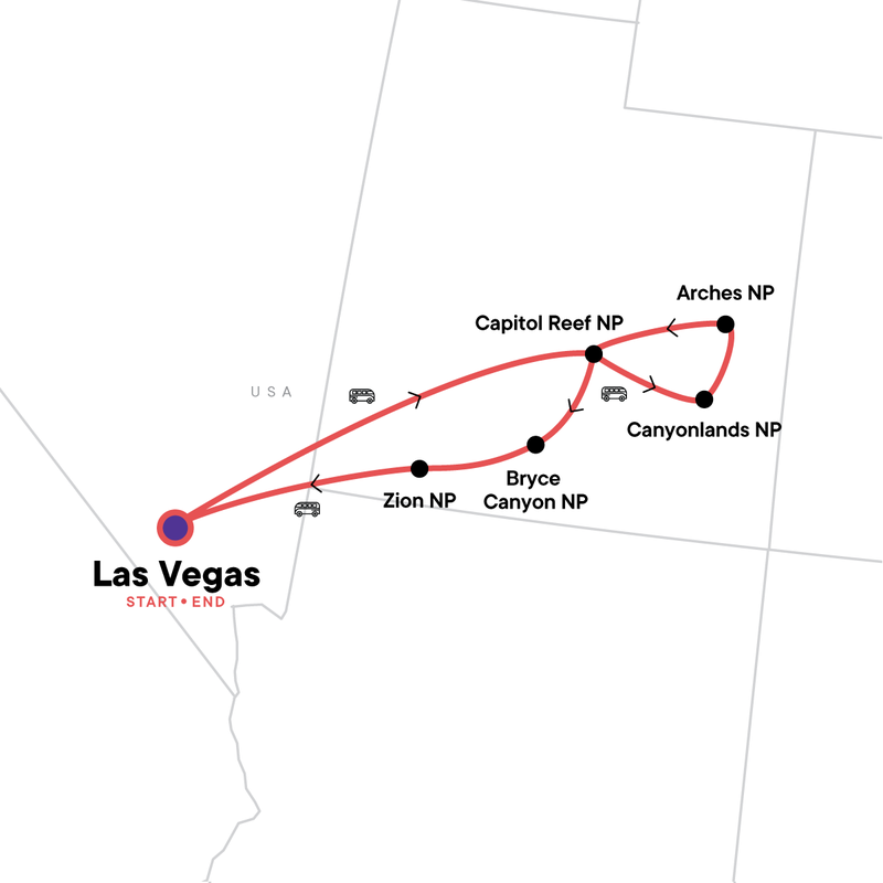
9 days, Las Vegas to Las Vegas

Itinerary Notes
During your time in Zion water shoes are available to rent for your hike through the Narrows. However, you may have to carry them with you for the remainder of the day. Which is why we recommend bringing your own lightweight water shoe/hiking shoe that you would also be comfortable hiking/walking in for the rest of the day to avoid carrying any extra weight.
Itinerary
Day 1Las Vegas
Arrive at any time.
There are no planned activities today until the evening welcome meeting, so check out the strip or Fremont Street.
This tour leaves Las Vegas in the morning on Day 2; if you would like to spend any additional time here, we recommend booking pre-tour accommodation.
Your Welcome Moment: Welcome Moment - Meet Your CEO and Group
Your opportunity to meet your CEO and fellow travellers, and learn more about your tour. Opt to join the group for a local meal afterwards. Don't forget to see the notice in the lobby (or ask reception) for the official time and place to meet up with the group.
Day 2Las Vegas/Capitol Reef National Park
Travel to Capitol Reef National Park. Known for its geologic monocline, discover the cliffs, canyons, petroglyphs and orchards that make up the park. Learn about the geology and the ancient inhabitants who created the petroglyphs still visible on the cliff walls. After dark, look up at Capitol Reef’s starry night, designated a Gold Tier "International Dark Sky Park".
Please note several of the trails we use do not have water accessible. Please bring a bottles/bladder with a capacity of 3 litres. Unexpected trail or road closures may prevent hiking on some of the listed routes. Should this event arise, we will substitute with an alternative hike.
Private Vehicle
Settle in and scan the scenery from the convenience of a private vehicle.
Petroglyphs at Capitol Reef National Park
Travel through twisting canyons, massive domes, monoliths, and spires of sandstone in this stunning and surreal National Park. Stop to look at petroglyphs etched in rock walls (keep an eye for bighorn sheep) dating back to 1300 C.E. when native people of the Fremont Culture made their home at Capitol Reef.
Stargazing in a Dark Sky Park
Gaze up at the starry, starry night in this designated gold-tier International Dark Sky Park. Far away from city lights, surrounded by the vastness of Capitol Reef's majestic peaks and valleys, you'll never see the Milky Way (or the night sky) in quite the same way.
Meals included:
DinnerDay 3Capitol Reef National Park/Moab
Set off in the morning to hike through the Waterpocket Fold, an 87 mile "wrinkle" in the earth's surface. Climb through canyons and narrows to reach Cassidy Arch and panoramic views of this natural wonder. In the afternoon, continue to Moab, an adventure capital of the southwest and the gateway to both Canyonlands and Arches National Parks. Depending on the season and if you still have energy, head to Dead Horse State Park to take in the views from one of the most photographed spots in the region.
Capitol Reef National Park Visit
Travel through twisting canyons, massive domes, monoliths, and spires of sandstone in this stunning and surreal National Park. Stop to look at petroglyphs etched in rock walls and painted pictographs that are sacred remnants of ancient Indians.
Waterpocket Fold and Cassidy Arch Hike
Formed by a dramatic warp in the earth's crust (known as a monocline), Waterpocket Fold is Capitol Reef's defining geologic feature. Hike through narrow canyons before reaching the trailhead to Cassidy Arch - a dramatic rock formation with incredible views of the valley. With plentiful nooks and crannies carved into the red rock, it's easy to see why the infamous outlaws Butch Cassidy and the Sundance Kid once chose to make the Arch their hideaway.
Hiking distance: 5.5km (3.4 mi) Elevation change: 240m (670 ft).
Private Vehicle
Settle in and scan the scenery from the convenience of a private vehicle.
Dead Horse Point State Park Visit
Stop in Dead Horse Point State Park to watch the hues of the light play on the canyon walls and river. Get those cameras ready!
Meals included:
Breakfast | Lunch | DinnerDay 4Canyonlands National Park
Travel to the Needles District of Canyonlands National Park. Stop at Newspaper Rock State Historical Monument, the largest known collection of petroglyphs in the Southwest. Spend the day hiking through desert lands to explore eroded towers of sandstone and fissures in the ground on the Joint Trail to Chesler Park. Return to Moab for a night in the town.
Private Vehicle
Settle in and scan the scenery from the convenience of a private vehicle.
Newspaper Rock State Historical Monument Visit
With over 650 petroglyphs in a single area, think of a visit to Newspaper Rock as flipping through the news pages of generations past. Created by ancestral Puebloan people who lived, farmed and hunted along a nearby ancient river, examine the intricate carvings they made to document their way of life.
Canyonlands National Park VIsit
Uncover a wilderness of endless canyons and striking buttes carved by the Colorado River and its tributaries. Four distinct districts make up this National Park, preserving a colourful landscape eroded into countless canyons, mesas, and buttes by the Colorado River, the Green River, and their tributaries.
Joint Trail and Chesler Park Hike
Trek through the desert grasslands of Chesler Park and admire towering sandstone pinnacles that give this area its name: the Needles District. Follow the Joint Trail into deep, sometimes very narrow slot canyons, before emerging back into open space. Now you understand why it's called the Canyonlands.
Hiking distance: 7km (4.5 mi) Elevation change: 533m (1,750 ft).
Private Vehicle
Settle in and scan the scenery from the convenience of a private vehicle.
Meals included:
Breakfast | LunchDay 5Arches National Park
Rise early for sunrise from Delicate Arch Viewpoint. Enjoy breakfast in the park before exploring the densest concentration of arches in the world. Stand in awe at the over 2,000 sandstone arches ranging in size and shape that make up this park. Take a hike through Devils Garden to Landscape Arch, passing fins and spires en route. Continue to Double O Arch, bouldering over rocks to to reach the pinnacle views. Pass by the famous Balanced Rock, The Windows and Double Arches before heading west to camp for the night.
Private Vehicle
Settle in and scan the scenery from the convenience of a private vehicle.
Arches National Park Visit
Wander throughout this red rock wonderland filled with countless arches, hundreds of soaring pinnacles, massive fins, and giant balanced rocks carved and shaped by eons of weathering and erosion. Explore viewpoints and hike in this National Park that contains the world's largest concentration of natural stone arches.
Devils Garden Hike
Explore the Arches that make up this national park along the Devils Garden trail. Arches form as narrow rock walls (called "fins") erode over time, causing sections of the rockface to fall. Visit Landscape Arch, the longest in North America, with an opening of 93m (306 ft). Continue to Double O Arch, a challenging, steep section that requires hikers to scramble over rocks. Be rewarded with incredible views at the top, before heading back to the trailhead.
Hiking distance: 7km (4.2 mi) Elevation change: 152-244m (500-800 ft).
Private Vehicle
Settle in and scan the scenery from the convenience of a private vehicle.
Meals included:
Breakfast | Lunch | DinnerDay 6Grand Staircase-Escalante National Monument/Bryce Canyon National Park
Hit the road again, to travel along the scenic highway through the Grand Staircase-Escalante National Monument. Take in the mesas, canyons and arches that make up this diverse geological region. Set off on a hike and discover prehistoric petroglyphs and stunning waterfalls. Opt to cool off in the refreshing waters falling 38m (126 ft) to a natural swimming pool fed from Calf Creek Falls. Continue to Bryce Canyon National Park for the night. After the sun goes down, don't forget to look up to check out this renowned night sky while enjoying s'mores around the fire.
Private Vehicle
Settle in and scan the scenery from the convenience of a private vehicle.
Lower Calf Creek Falls Hike
Enjoy an easy hike through relatively flat terrain to get to Lower Calf Creek Falls. While you may see a few more hikers than on previous days, this trek is no less spectacular - especially once you sight the clear waters of Calf Creek and its 38m (126 ft) drop into a deep pool. Named for the natural "pen" where early pioneers and ranchers herded their calves for a much-needed drink, today visitors can opt to swim in this cool oasis.
Hiking distance: 10km (6 mi) Elevation change: 61m (200 ft).
Private Vehicle
Settle in and scan the scenery from the convenience of a private vehicle.
Meals included:
Breakfast | Lunch | DinnerDay 7Bryce Canyon National Park/Zion National Park
Set off early in Bryce Canyon National Park, and stare in wonder at the largest collection of hoodoos in the world as the sun rises! Take a hike into the amphitheater of Queen's Garden and Navajo Loop to walk amongst the hoodoos, walls and fins that make up this geological wonder. Continue to Zion National Park, traveling past towering cliffs and massive canyon walls, stopping at several viewpoints along the way. Once in the park hike the switchbacks of Angels Landing to reach sweeping views of the park. Stop at the end of the switchbacks or opt to keep climbing along the cables to the top.
Bryce Canyon National Park Visit
See a sight like no other at this giant forest of stone made up of collection of massive natural amphitheaters. This park contains hundreds of thousands of eroded spires, pinnacles, and other shapes as far as the eye can see.
Queen's Garden and Navajo Loop Hike
Trek through the most popular trail in Bryce Canyon to see its famous hoodoos - tall, thin spires of rock that seem to magically balance upon their dusty, red rock base. Begin your hike at Sunrise Point and make your way toward Queen Victoria, the trail's namesake rock formation. Continue through the amphitheater on Navajo Loop past Wall Street or Thor's Hammer, depending on trail conditions. Exit at Sunset Point before walking the Rim Trail back to our starting point. Soak in the views one last time - you'll want to take it all in.
Hiking distance: 4.6km (2.9 mi) Elevation change: 183m (600 ft).
Private Vehicle
Settle in and scan the scenery from the convenience of a private vehicle.
Angels Landing Hike
Take off for Angels Landing, an unforgettable hike that makes it to many peoples' bucket lists for a reason. Start your trek on the West Rim Trail and follow the river before sneaking through the scenic canyon. Head up a series of 21 switchbacks called Walter's Wiggles, to arrive at Scout Landing. From here, opt to continue the jaw-dropping climb up to the top of Angels Landing. In some places, the ridge becomes barely wide enough to set two feet in. Hold onto the chain for an incredible reward!
Hiking distance: 9km (5.4 mi) Elevation change: 457m (1,500 ft).
Meals included:
Breakfast | Lunch | DinnerDay 8Zion National Park
Spend the day discovering Zion National Park. Visit Observation Point before heading to the valley floor to trek through the river on one of the most popular hikes in the park, the Narrows. Admire monumental sandstone cliffs of cream, pink, and red that tower into the sky and opt to turn around at any point. Experience diverse plant and animal life in this narrow slot canyon as the park transitions from desert to forest. Gaze at the awe-inspiring beauty of the high plateaus, striking towers, temples, mesas, and the earth's tallest-known sheer sandstone walls. After returning to camp, head into the charming town of Springdale to celebrate the accomplishments of the last week.
Please note that unexpected trail closures due to risk of flooding may arise in The Narrows. Should this happen, we will substitute with an alternative hike.
While water shoes are available to rent you may have to carry them with your for the remainder of the day. We recommend bringing your own lightweight water shoe/hiking shoe that you would also be comfortable hiking in for the rest of the day.
While the trail to Angels Landing is not included in this itinerary, it is available to be done independently. If you’re interested in continuing to the top, you must apply ahead of time for a permit via the National Park’s lottery system at this website: https://www.nps.gov/zion/planyourvisit/angels-landing-hiking-permits.htm.
Zion National Park Visit
Admire monumental sandstone cliffs of cream, pink, and red that tower into the sky. Experience diverse plant and animal life, and wade through water in a narrow slot canyon as the park transitions from desert to forest. Gaze at the awe-inspiring beauty of the high plateaus, striking towers, temples, mesas, and the earth's tallest-known sheer sandstone walls.
The Narrows Hike
Known as one of Utah's best slot canyon hikes, The Narrows takes you through towering canyon walls along the Virgin River (and yes, this means walking in water!). Enjoy some of the park's best scenery, stop to take photos, and don't forget to watch your footing. Opt to make your way back at any point.
Hiking distance: 6.4km (4 mi) Elevation change: 102m (334 ft).
Observation Point Hike
Trek up to Zion NP's famed Observation Point, where views of the valley below stretch out to the horizon. Classified as one of the park's strenuous hikes (given its elevation), the route consists of switchbacks before reaching shady Echo Canyon. Continue the uphill climb until the trail levels out towards the peak. Gaze out across the valley to Angels Landing and appreciate just how far you've come.
Hiking distance: 12.9km (8 mi) Elevation change: 655m (2,150 ft).
Meals included:
Breakfast | LunchDay 9Zion National Park/Las Vegas
Take the short drive from Zion to Las Vegas. Tour ends on arrival. Onward travel should be booked no earlier than 3pm.
Departure Day
Not ready to leave? Your CEO can help with travel arrangements to extend your adventure.
Private Vehicle
Settle in and scan the scenery from the convenience of a private vehicle.